Tìm kiếm: gần-tâm

Dự báo trong 24 giờ tới, bão hầu như ít dịch chuyển, sau đó có khả năng đổi hướng, di chuyển chậm về phía Tây và có khả năng mạnh thêm.

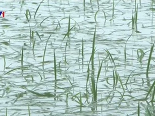
Theo báo cáo nhanh ngày 6/11 của Văn phòng Ban chỉ huy tỉnh Bình Thuận, đêm 5/11, rạng sáng 6/11, mưa to đã gây một số thiệt hại.

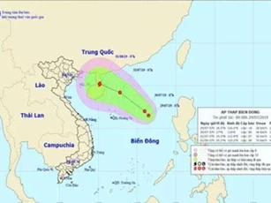
Hồi 22h ngày 6/11, vị trí tâm bão ở vào khoảng 13,5 độ Vĩ Bắc; 116,6 độ Kinh Đông, cách đảo Song Tử Tây (quần đảo Trường Sa) khoảng 330km về phía Đông Bắc.

Căn bệnh ung thư dạ dày của ba anh em bắt nguồn từ thói quen không thích ăn rau xanh và tiêu thụ một lượng lớn đồ ngâm, đồ muối trong bữa ăn hàng ngày.
Ngoài việc hơn 1.300 ngôi nhà bị hư hỏng và tốc mái, lúa, gia súc, gia cầm và thủy sản đều bị thiệt hại nặng sau bão số 4.
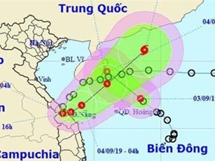
Theo Trung tâm Dự báo khí tượng thủy văn Quốc gia, sáng sớm nay (3/9), áp thấp nhiệt đới gần bờ đã đi vào đất liền các tỉnh từ Quảng Trị đến Thừa Thiên Huế. Cơn áp thấp nhiệt đới này được dự báo sẽ đổi hướng và trở lại Biển Đông.
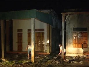
Theo báo cáo công tác trực ban phòng chống thiên tai ngày 1/9, bão số 4 đã gây thiệt hại nặng về người và tài sản.

Theo Trung tâm Dự báo khí tượng thủy văn Quốc gia, dự báo, từ sáng sớm đến trưa mai (30/8), bão số 4 sẽ đi vào đất liền các tỉnh từ Nghệ An đến Quảng Bình với sức gió mạnh cấp 8-9, giật cấp 11, sau đó suy yếu thành áp thấp nhiệt đới.
Theo Trung tâm Dự báo khí tượng thủy văn Quốc gia, hiện nay trên Biển Đông đang xuất hiện một áp thấp nhiệt đới ở khu vực Quần đảo Hoàng Sa.

Theo Trung tâm Dự báo khí tượng thủy văn Quốc gia, khoảng chiều tối đến tối nay (2/8) bão số 3 (tên quốc tế là Wipha) sẽ đi vào đất liền các tỉnh từ Quảng Ninh đến Thái Bình với sức gió mạnh cấp 7-8, giật cấp 10-11.

Trung tâm Dự báo khí tượng thủy văn Quốc gia nhận định, bão số 3 sẽ vào đất liền các tỉnh Quảng Ninh đến Nam Định trong nhiều giờ tiếp theo. Từ hôm nay (1/8), nhiều tỉnh phía Bắc được cảnh báo có mưa to, có nơi mưa rất to.

Chuyên gia khí tượng thủy văn đánh giá, bão số 3 có diễn biến rất phức tạp về cường độ và hướng di chuyển. Dự kiến, khoảng chiều mai (1/8), bão số 3 sẽ đi vào Vịnh Bắc Bộ.

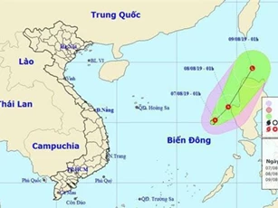
Theo Trung tâm Dự báo khí tượng thủy văn Quốc gia, sáng ngày 30/7, vùng áp thấp trên Biển Đông đã mạnh lên thành áp thấp nhiệt đới.
Sáng nay (29/7), trên vùng biển phía Đông khu vực Bắc Biển Đông xuất hiện một vùng áp thấp.

Chiều ngày 16/7, áp thấp nhiệt đới ở phía Đông đảo Lu-dông (philippines) đã mạnh lên thành bão số 3 (bão Danas) gần biển Đông. Vị trí tâm bão cách đảo Lu-dông khoảng 330km về phía Đông, giật cấp 10.
End of content
Không có tin nào tiếp theo