Tìm kiếm: áp-thấp--nhiệt-đới
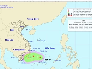
Theo kịch bản xấu nhất, bão số 9 sẽ dịch chuyển đến các khu vực từ Bình Thuận đến Bà Rịa - Vũng Tàu và gây gió mạnh cấp 6-7, nhưng khả năng cơn bão số 9 sẽ dịch chuyển sang hướng Nam vẫn có thể xảy ra. Cơn bão số 9 cường độ có thể lên tới cấp 9-10.

(DNVN) – Trận mưa lũ "lịch sử" ngày 17 và 18/11 vừa qua, khiến một số khu, cụm công nghiệp bị ngập sâu từ 0,4 đến 1m, dẫn đến nhiều doanh nghiệp bị thiệt hại nặng nề. Bão số 9 tiếp tục đe doạ, các doanh nghiệp tại đây lại phải “căng mình” chống bão.

Do ảnh hưởng của hoàn lưu bão số 9 kết hợp với không khí lạnh, từ chiều tối và đêm nay (23/11) đến ngày 26/11, ở các tỉnh từ Thừa Thiên Huế đến Bình Thuận và Nam Tây Nguyên có mưa rất to (300-500 mm/đợt); Bắc Tây Nguyên và Nam Bộ có mưa to (100-200 mm/đợt).

Học sinh trên địa bàn tỉnh Khánh Hòa được nghỉ học từ chiều nay đến hết Chủ nhật tuần này nhằm đảm bảo an toàn trước tình hình cơn bão số 9 đang áp sát các tỉnh duyên hải Nam Trung Bộ.

(DNVN) – Đó là một trong những nội dung quan trọng trong công điện khẩn của UBND tỉnh Khánh Hoà về việc ứng phó với cơn bão số 9, được phát đi chiều 22/11.

Đợt gió mùa Đông Bắc mới tiếp tục tràn về miền Bắc, đồng thời diễn biến di chuyển của cơn bão số 9 trở nên khó lường, bắt đầu đổ bộ vào khu vực miền Trung.

Ban ngày các tỉnh Bắc Bộ có nơi trên 31 độ, song từ đêm nay, trời chuyển rét với nhiệt độ thấp nhất phổ biến 16-19 độ, có nơi chỉ còn 13 độ.
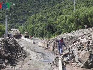
Theo thống kê đến tối 19/11, mưa lũ tại tỉnh Khánh Hòa đã làm 17 người chết, 3 người mất tích, hơn 30 người bị thương.

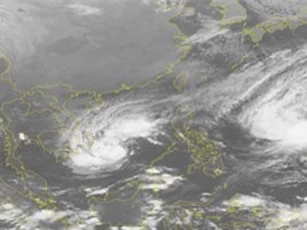
Trong 24 đến 48 giờ tới, dự báo bão di chuyển theo hướng Tây Bắc, mỗi giờ đi được khoảng 25km và vào Biển Đông, sau đó có khả năng mạnh thêm.

Cơn bão mới (bão số 9) sẽ còn nguy hiểm hơn rất nhiều so với cơn bão số 8 và sẽ mang theo mưa rất lớn.

(DNVN) - Thủ tướng Chính phủ vừa có Công điện gửi lời thăm hỏi, chia buồn sâu sắc tới thân nhân các gia đình có người bị thiệt mạng do mưa lũ, chia sẻ những khó khăn, mất mát của đồng bào, chính quyền các địa phương.

(DNVN) – Chiều 18/11, UBND tỉnh Khánh Hòa đã tổ chức cuộc họp khẩn với các sở, ban, ngành và UBND TP. Nha Trang, để triển khai công tác khắc phục hậu quả nặng nề do mưa lũ gây ra.
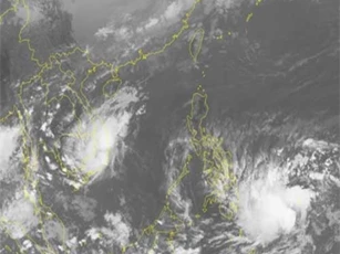
Trưa ngày 18/11, áp thấp nhiệt đới ở ngay trên vùng ven biển các tỉnh Ninh Thuận đến Bình Thuận, với sức gió vùng gần tâm mạnh cấp 6, giật cấp 8.
Dự báo của Trung tâm Dự báo Khí tượng thủy văn Trung ương, từ đêm 17/11 đến ngày 19/11 ở các tỉnh ven biển Nam Trung Bộ, Nam Tây Nguyên và Nam Bộ có mưa vừa, có nơi mưa to đến rất to và rải rác có dông.

Dự báo thời tiết 17/11: Sáng nay, bộ phận không khí lạnh sẽ ảnh hưởng yếu đến các tỉnh phía Đông Bắc Bộ. Khoảng đêm mai sẽ tăng cường mạnh hơn.
End of content
Không có tin nào tiếp theo